



| NATIONAL WATERWAY (NW-2) |
|---|
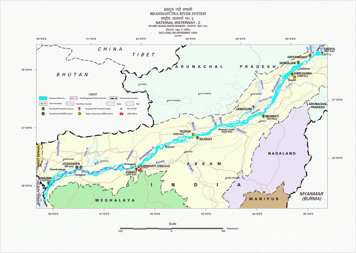
The River Brahmaputra, having a length of 891 km between the Bangladesh Border and Sadiya in the State of Assam, was declared as National Waterway No. 2 (NW-2) on 1st September 1988. The Inland Waterways Authority of India (IWAI), constituted under the IWAI Act, 1985 (82 of 1985), is responsible for the development, regulation, and maintenance of the waterway for navigation.
IWAI is undertaking continuous developmental works to improve the navigability of NW-2, including fairway maintenance, dredging, and navigational aids. As per prescribed standards, IWAI maintains a Least Available Depth (LAD) of 2.5 metres in the Bangladesh Border–Neamati stretch (629 km), 2.0 metres in the Neamati–Dibrugarh stretch (139 km), and 1.5 metres in the Dibrugarh–Sadiya stretch.
At present, NW-2 is utilized by vessels operated by the Government of Assam, Indian Army, Border Security Forces, tourism organisations, and private operators. The waterway supports passenger movement, cargo transportation, and tourism, with long cruise tourist vessels regularly operating between Pandu and Majuli Island near Neamati. During the navigation season from October to May, Over Dimensional Cargo (ODC) is also transported through the waterway, highlighting its strategic and economic importance.
To strengthen inland water transport in the North Eastern Region, IWAI is implementing a comprehensive development programme on NW-2, including navigation infrastructure, terminals, jetties, dredging support, and multimodal connectivity. Significant investments have been approved for the development of NW-2, ship repair facilities at Pandu, multimodal terminals, and associated road connectivity, aimed at improving cargo and passenger movement along the Brahmaputra corridor.
| Terminals |
|---|
National Waterway-2 (Brahmaputra River, Dhubri to Sadiya) hosts a network of fixed and floating terminals to support the handling of cargo vessels, passenger ferries, Ro-Ro services, and multimodal activities. Terminals are strategically located to enhance connectivity, facilitate river transport operations, and integrate with road/rail infrastructure in the North East Region.
The following terminals are operational or under development on National Waterway-2 to support inland water transport, cargo handling, and passenger movement. IWAI maintains both permanent (fixed) and floating terminal facilities, equipped with handling infrastructure, navigational support, and connectivity to hinterland transport networks.
| S.No. | Terminal Location | Type | Purpose / Major Commodities / Operations |
| 1 | Hatsingimari | Temporary Ro-Ro terminal with a steel crane pontoon is provided. | Temporary Ro-Ro terminal providing Ro-Ro service between Dhubri and Hatsingimari. Operational Ro-Ro service. (Iwai) |
| 2 | Dhubri | Fixed RCC Ro-Ro terminal with 2 godowns and a crane pontoon is provided | Handles Ro-Ro vessels, cargo vessels, passenger ferries, and stone chips. Customs and immigration facilities established; shore crane present. DGPS station installed. (Iwai) |
| 3 | Jogighopa | Floating terminal with a crane pontoon. | Supports multimodal connectivity, coal and stone chips cargo handling, and logistics integration. Declared as Port of Call; DGPS installed. (Iwai) |
| 4 | Pandu (Guwahati) | Fixed/permanent terminal with two godowns and RCC jetties | Major terminal on NW-2 with low- and high-level jetties; shore and container cranes; rail connectivity via BG siding. RO-PAX ferry operational. (Iwai) |
| 5 | Tezpur | Floating terminal with a steel pontoon. | Cargo handling and local ferry service with steel pontoon. (Iwai) |
| 6 | Biswanath Ghat | Floating terminal | Projected for handling PDs, foodgrain, and ODC cargo; DGPS station installed. (Iwai) |
| 7 | Silghat | Floating terminal with a steel pontoon. | Cargo vessels and local ferry operations; designated Port of Call on IBP route. (Iwai) |
| 8 | Neamati | Floating terminal with a steel pontoon. | Cargo and passenger services; Ro-Ro terminal proposed; RO-PAX vessels operate to Majuli. (Iwai) |
| 9 | Bogibeel | Floating terminal with steel pontoon. | Supports cargo and tourism operations; floating jetties in progress; foodgrain transport trialled. (Iwai) |
| 10 | Dibrugarh | Floating terminal with steel pontoon | Cargo and local ferry service terminal; ODC expected; DGPS station installed. (Iwai) |
| 11 | Sengajan / Panbari | Floating terminal with a crane pontoon | Supports movement of Indian Army vessels; floating terminal maintained. (Iwai) |
| 12 | Oriumghat (Sadiya) | Floating steel pontoon | Facilitates passenger connectivity, BSF / Army access, and ODC/project cargo; land acquisition completed, development planned. (Iwai) |
| Navigation Facilities |
|---|
In order to provide the safe navigation for various cargo vessels, tourist vessels with foreign tourists, local regular service by private operators and mechanized country boats , day navigation marks with bamboos and navigational lights fixed on country boats / beacons have been provided from Bangladesh Border to Dibrugarh as detailed below:
| S. No. | Stretch & Distance in Km | Number of day marks | Solar operated Navigational lights fixed on country boats/ Beacons | |
| Lean Season | Flood Season | |||
| 1 | Bangladesh Border - Pandu (255 km) | 293 | 147 | 255 |
| 2 | Pandu- Neamati (374 Km) | 561 | 281 | 200 (up to Silghat) |
| 3 | Neamati-Dibrugarh (139 km) | 139 | 135 | |
| 4 | Dibrugarh- Oriumghat/Sadiya (92/123 Km) | 140 | 105 | |